This is how the Crisis Map CAR works


In early April we introduced the experimental platform of the Humanitarian Crisis Map for the Central African Republic (CAR).
On Saturday June 16, after two months of feedback, comments and adjustments, we officially launched in Bangui the final product: Crisis Map CAR (www.cartehumanitaire-rca.org) – in its French name Carte de Crises – Centrafrique.
What is it?
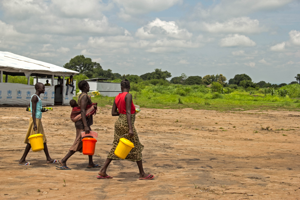
Crisis Map CAR enables bidirectional information sharing between local communities and humanitarian actors through SMS, crisis mapping and more important and accessible to the, community radio stations, the only source and information for many people around the country.
The goal of this interactive platform is to positively influence the overall situational awareness of the humanitarian community in the CAR to promote faster and more efficient decision-making and response. At the same time, information/actions from humanitarians will be accessible to local communities through reports produced by community radio stations, creating a stronger 2-way communication that, and that’s why we are doing this, will improve community participation &; community resilience.
On the one hand, this Internews’ project builds on the great work that the Network of Journalists for Human Rights (RJDH) does at gathering and sharing first hand information from vulnerable populations in real time through the reports shared by 11 community radio stations and over 20 regional correspondents pretty much on a regular daily. On the other hand, humanitarian organizations in CAR can also insert information into the map, improving communication, coordination and advocacy. OCHA, MSF, UNICEF have already contributed information and reports and we expect many more reports and information to be shared so the Network can put it on the map and equally important, share it back with community radios, correspondents and therefore with local populations –we’ll keep you posted on how that sharing process goes.
Crisis Map CAR is an Ushahidi platform - "Ushahidi" means witness in Swahili. The platform was created in Kenya in the wake of the 2007/8 post-election crisis to map violence and peace efforts on the basis of reports submitted via mobile phones, e-mail and social media. After the successful use of this platform by various actors in subsequent humanitarian crises such as Haiti, Libya, Japan and Colombia, Internews has now introduced Ushahidi in CAR, and put local media at its core.
How does it work?
Prior to publication, all information is processed, geo-located and validated as coming from an identifiable source.
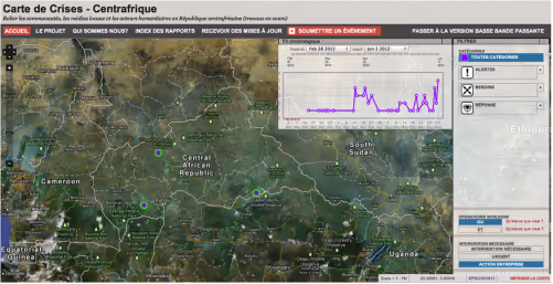
The information visible on the homepage is the most recent - two weeks old, but it is possible to access to older reports by clicking on "Fil Chronologique" at the top of the map, which opens a chorological table charting reports by week. (For the time being -due to the operational language in country- Crisis Map CAR is in French only).
The purple dots represent all reports, and the number indicated the number of reports per area. It is possible to zoom in and out according to the area of interest.
Users can select information by clicking on the dropdown menu to the right of the map, divided into three categories (each will appear with their specific logo);
- Alerts contain information that is not actionable, but which is important for situational awareness and understanding the humanitarian context in CAR. Subcategories (placed in alphabetical order) include information relating to security, such as armed clashes or violent demonstrations, or of logistical nature as roadblocks or UNHAS (United Nations Humanitarian Air Services) flight status.
- Needs contain information on the humanitarian needs of local population. Subcategories include thematic clusters such Health and Nutrition / Food Security, as well as topics specific to the RCA, such as Witchcraft or Refugees flows.
- Responses provide information on humanitarian actors’ interventions. The subcategories are the same as those in the needs category, in order to visualize the relationship between the two.

Also, -by clicking on the lower part of the dropdown menu to the right of the map- it is possible to select information which requires intervention (intervention nécessaire), is urgent (urgent) or that shows actions taken (action entreprise).
A low bandwidth version is available that takes into account the difficulty of connecting to the internet signal in CAR. Please use Firefox or Chrome as your browser when you use this platform.
Interacting
Humanitarian Crisis Map for the Central African Republic (CAR)is public and accessible to all. The reports in the map do not disclose confidential or sensitive information. That stated, not everybody can directly publish information on the map. Only officially approved humanitarian organizations present in CAR and the Network of Journalists for Human Rights, can directly publish content. You can contact the Network for more information: [email protected].
Once an organization has acquired an account, it can insert information directly into the map. The content inserted must include descriptive information such as date, location, category (i.e. alerts, needs, responses) and status (i.e. actionable, urgent, action taken). It is also possible (and advisable) to add photos, video and links to websites.
The added value of Crisis Map CAR is its brevity and speed in humanitarian information sharing. It is a tool to provide updates in real time to multiple partners – especially useful during unfolding crisis. For example, a humanitarian organization may share: "Health assessment ongoing in area X" (to identify gaps), "Problems of access to the collapsed bridge on the axis Y" (critical information if another organizations is planning a field trip on the same route the following day), or "Distribution of Z goods completed"(to avoid duplication). The length and depth of the report however, is up to each registered organization, which is free to share as much or as little detail as it chooses to.
Receiving Updates and Searching for Reports
Crisis Map CAR has been designed to be user friendly and time efficient. Hence, users are not obliged to open the map to see updated information – they can simply request for the information to be sent to their e-mail whenever updates are posted.
To receive updates, please click on "Recevoir des mises à jour" and select the type of information of interest, be it thematic, geographical or a combination of both i.e. "Water and Sanitation" or “the city of Obo” or "Needs - Shelter and Non Food Items – Ndelé.
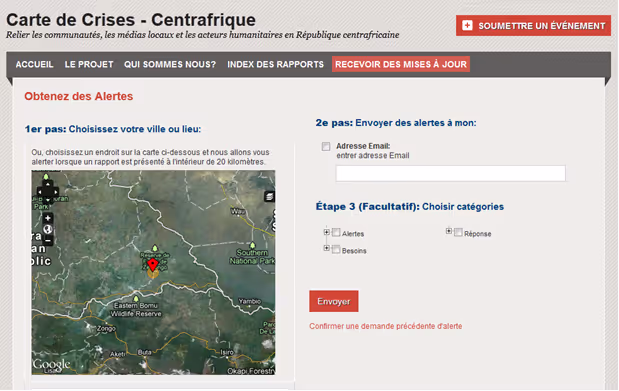
For more specific search criteria, click on "Index des rapports." This section allows to view all the reports in the Crisis Map CAR and to select items with several combinations search criteria such as subcategories, location, source, etc.
BBQ Launch
After bilateral meetings, personalized trainings to humanitarians and the formal presentation to the Humanitarian and Development Partnership group, on the evening of Saturday June 16 Internews and the RJDH had the pleasure to host a barbeque in our office/house to officially launch the Crisis Map CAR. Attended by friends and strategic partners in a homey and informal context, we shared food, good talks and – needless to say- our project presentation.
We look forward to monitor the humanitarian information exchange into the map in the upcoming weeks, while continuing our outreach and disseminations activities.
I also want to suggest you reading the blog post of my colleague Anahi Ayala, our Innovation Advisor at the core of this project, with a moretechnical and affordable explanation of the map.
Stay tuned, far more to come.
Raimondo Chiari – Humanitarian and Media Liaison Officer
Internews – Central African Republic
[email protected](link sends e-mail)
@R_Chiari
Stay updated
Sign up for our newsletter to receive regular updates on resources, news, and insights like this. Don’t miss out on important information that can help you stay informed and engaged.


Explore Elrha
Learn more about our mission, the organisations we support, and the resources we provide to drive research and innovation in humanitarian response.