Spreading the Love for Open Aerial Imagery


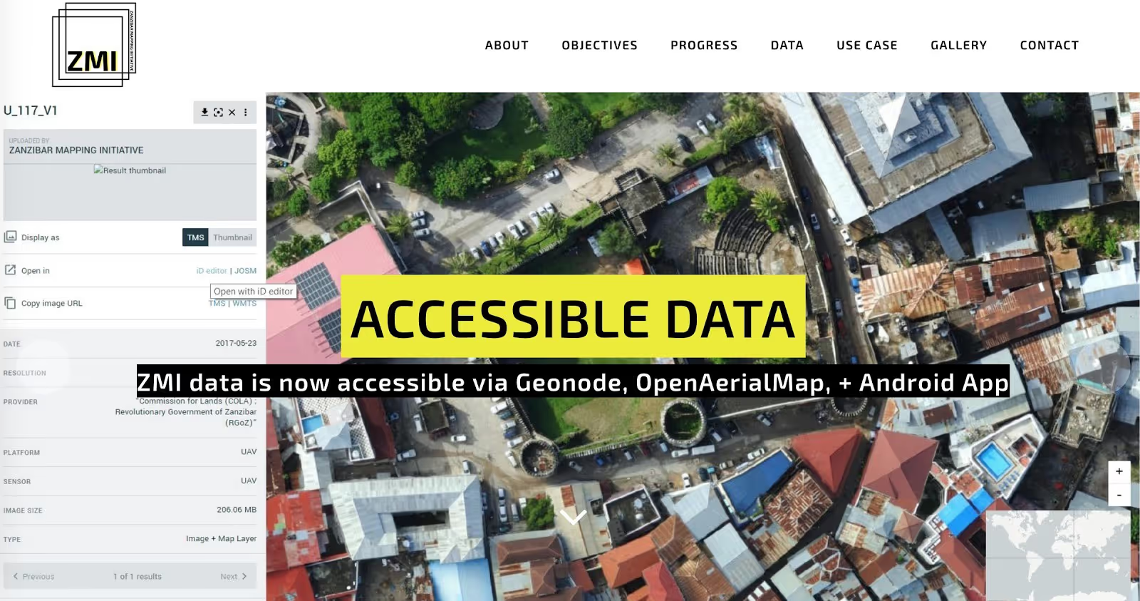
In 2016, a group of local innovators in Zanzibar decided to map their entire island with drones. With support from the World Bank and other partners, the Zanzibar Mapping Initiative (ZMI) created a high resolution map of over 2300 square kilometres that has unprecedented resolution, and would have not been possible with satellites or manned aircraft. Collecting and processing the data was only half of the effort to make the imagery really useful. Sharing and making this huge amount of data accessible for the public good was possible through OpenAerialMap (OAM) and its scalable design. The local and international mapping communities can now access every single pixel of this incredible imagery mosaic, by browsing the OAM catalog, opening the ZMI app on their phones, or by connecting mapping tools to OAM’s interoperable web services (WMTS and TMS). The local government and the Zanzibar Commission for Lands is now using maps derived from this high resolution imagery for better planning, land tenure and environmental monitoring.
Earlier in 2018, tropical cyclone Gita made landfall on the small island country of Tonga in the South Pacific ocean, causing an estimated damage of over $180M. With support from the Australian government and the World Bank, a few days after the event, a team of UAV pilots deployed and mapped the island of Tongatapu, which was most affected by the disaster. At greater than 10cm ground resolution and covering the entire island extent of 260 square kilometres, the resulting dataset is a massive collection of several hundred gigabyte files. It would have been impossible to make this valuable imagery available to everyone who needed it, from ground responders, to remote analysts, to local decision makers, just by traditional “hard disk” delivery. With a single upload process to OAM, all of the imagery instantly became accessible to anyone. The Global Facility for Disaster Reduction and Recovery (GFDRR) had also supported the creation of previous drone imagery dataset in fall 2017 through the UAV4Resilience project, and was then able to quickly compare before/after image pairs for assessing damage, and inform recovery and reconstruction funding efforts.

OpenAerialMap has grown steadily over the past years to become the reference platform for sharing and accessing openly licensed imagery. Humanitarian mappers rely on OAM’s scalable infrastructure every day to create fresh geospatial data for areas of the world that don’t exist on any official map. The Missing Map initiative, led by the American Red Cross and Médecins Sans Frontières (MSF) has been responding to several humanitarian crises in 2018, from earthquakes, to recent Ebola outbreaks, and rallying international and local communities around the HOT Tasking Manager where they automatically plug in imagery from OAM.
Thanks to generous support from Elrha's Humanitarian Innovation Fund (HIF) and other donors, OAM has been presented at several events in 2017 and 2018, including international mapping conferences and expert meetings of leading humanitarian organisations and the United Nations. Satellite imagery providers and drone pilots in many countries now have a common platform where they can share imagery easily and reliably. Integrations that have been developed with other mapping software such as OpenDroneMap (ODM) and DroneDeploy further streamline the steps from collecting imagery to making it accessible online in standard GIS format. And, being OAM an open source software, it can easily be extended and deployed on other infrastructures. To demonstrate its portability, HOT was invited to participate in the Amazon Web Services (AWS) Public Summit in Washington DC, where a version of OAM was deployed on AWS Snowball Edge, to simulate a real response scenario.
The team contributing and building OAM has a shared belief that open imagery should be truly accessible and usable. This requires having modern and broadly adopted data standards, as well as well defined imagery licenses. Through the pioneering experience of developing OAM, it’s been possible to inform the design of innovative specifications such as the Cloud Optimized GeoTIFF (COG) and Static SpatioTemporal Asset Catalogs (STAC), which are shaping the future of geospatial technology.
As more providers join OAM and images are added daily from anywhere in the world, we continue our mission to support humanitarian organisations and beyond with accessing open imagery — help us spread the love!
Stay updated
Sign up for our newsletter to receive regular updates on resources, news, and insights like this. Don’t miss out on important information that can help you stay informed and engaged.


Explore Elrha
Learn more about our mission, the organisations we support, and the resources we provide to drive research and innovation in humanitarian response.