Server development for early warning dissemination in progress

To ensure that future collaborations are committed, a draft MOU between CARE Bangladesh and its technical and implementing partners has been actioned and finalised. All relevant partners and stakeholders will be present for a MOU signing ceremony to be organised by mid July 2014.
The Telecommunication service provider AirTel Bangladesh Ltd, in association with CARE Bangladesh, has conducted a feasibility study on the proposed device life cycle. In this process, they have consulted with the (deep sea) fishermen and collected information on their technical knowledge on: device operations, available resources in the boat and possible requirements for proposed device installation and operations. Based on their study findings, AirTel has submitted a proposed devices’ specification report for proceeding on a Purchase Request (PR) process. CARE Bangladesh has taken all the necessary initiatives e.g. engaged the technical team members to review the device specification and next proceedings. All should be completed by July 2014 and devices distributed by mid August 2014.
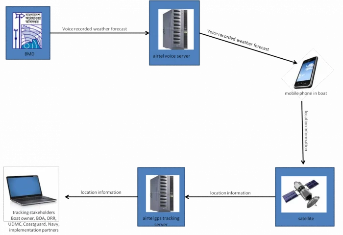
AirTel has engaged a technical team to develop a server which will be used for dissemination of early warning messages among the deep sea fishermen. They are also working on the establishment of network coverage in the deep sea. The team is in communication with the Bangladesh Telephone Regulatory Commission (BTRC) on this topic. Also, CARE is coordinating with the Bangladesh Meteorological Department (BMD) and AirTel on effective execution of early warning messages. The BMD will provide a recorded voice file containing the latest weather forecast and through the telecom, the weather forecast will be disseminated to all the handset devices by a scheduled time. If a boatmen/owner should miss the call, they can listen/retrieve it by dialing a phone number.
A useful web portal will be provided to the stakeholders to see the current location of the boat/s. The web based system will allow the users to see the followings: (a) Current location of the boat/s with latitude and longitude (b) Historical locations of the boat and (c) See a number of boats on a map at a time with location.

Figure 1: Proposed vessel tracking system for weather forecasting and location tracking
Project overview:
The project addresses the need for sufficient lead time on warnings of rough sea events through satellite-based weather signals. The digital tracking of fishing vessels also allows for more efficient and precise rescue missions in the event of capsizing and helps to protect the lives and livelihoods of fishermen who are vulnerable to frequent and severe weather events at sea. Community capacity in early warning and DRR is being strengthened through training and adoption of this system, thereby promoting a proactive rather than reactive approach to disaster.
Stay updated
Sign up for our newsletter to receive regular updates on resources, news, and insights like this. Don’t miss out on important information that can help you stay informed and engaged.
Related articles


.png)
Explore Elrha
Learn more about our mission, the organisations we support, and the resources we provide to drive research and innovation in humanitarian response.