Ecosystem and Community Risk mapping‚ and building trust in preparation for Bio-Rights loans for community risk mitigation works
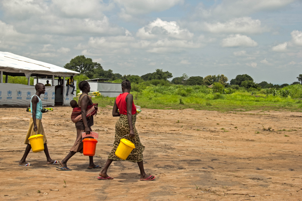


The basic principle of the Bio-rights model consists of small funds for communities for local Disaster Risk Reduction activities, considering increased risks by climate change and the role of ecosystems in reducing vulnerabilities. According to this model the financing (loan) is converted into a grant depending on the degree of success of families and community in the implementation of the mitigation works, based on environmental conservation, restoration and protection.
Of utmost importance for successful testing and implementation of this model, is analysis of the local context and cooperation and trust building with local actors.
In the first phase of the project, for the identification and prioritization of communities, meetings were held the team of the on-going programme in the project area, the Partners for Resilience Programme (PfR), with local organization Vivamos Mejor, and local government to review the intervention strategy, project resources and local context.
Watershed Approach Based on consultation with actors, it was decided that the Bio-Rights project would focus its efforts in communities neighbouring the PfR programme areas in Sololá department, Guatemala, with high levels of vulnerability:
- Pasaqajuyub village, municipality of Santa Catarina Ixtahuacán,
- Tzamabaj village, municipality of Santa Catarina Ixtahuacán,
- Chicorral village, municipality of Santa Catarina Ixtahuacán,
- Pakim village, municipality of Nahualá.
All communities are geographically located in the middle level of the Masá river basin. Originally the project was planned to focus exclusively on communities in the municipality of Nahualá, but during the risk analysis methodology used under the Climate Vulnerability and Capacity Analysis (CVCA), and in line with an analysis of risks that are related to upstream conditions, the Bio-Rights framework needs to be implemented considering the watershed approach and not the political and administrative divisions.
Risk Analysis A risk analysis of the sub-basin and community priorities under the CVCA methodology, has identified the risk conditions at the community perception level. This was supplemented with the technical-scientific component of a cartographic and biophysical variables analysis, including an analysis of landslide susceptibility using the methodology of Mora-Bharson, involving the analysis of various physical factors such as geology, geomorphology, land use, slope orientation, and slope percentage and triggering factors, in this case the rain.
Based on these analyses a landslide susceptibility map of the sub basin of Masá river region was created, which allowed a comparative analysis of current perceptions against historical data, that allows to better outline risk trends in the zone. This information will inform and support communities in taking appropriate action and investing in appropriate ecosystem based mitigation measures.
Consultations and local involvement This risk analysis has informed the intervention model of the project and consultation with leaders in each community. These consultations have involved: Community Mayors, Principals (traditionally recognized authorities), forest rangers, members of water committees and community development councils (COCODE), and in some cases, members of Local Disaster Reduction Coordinators (COLRED) who’s capacity is built.
On the basis of dialogue and reflection in each community, this has created trust and more clarity of how to invest in risks and to ensure active participation of the community in work processes, under the principle of respect for the views and the cultural dynamics of the Mayan communities in terms of organization, participation and natural resource management. In addition, formal meetings were held with potential strategic partners identified, such as Association of Friends of the River Ixtacapa, which can contribute resources to this initiative when it ends.
Alongside the risk analysis, we have developed and validated an Outcome Mapping methodology , which will support in monitoring and evaluation in each of the communities.
The upcoming commitment for the project team, that was agreed during community consultations, is conducting community meetings where decisions will be made together with the each community, with regard to the prioritization of practical eligible mitigation measures, to ensure a participatory process on defining the conditions under which the communities will receive the Bio-Rights funds.

Stay updated
Sign up for our newsletter to receive regular updates on resources, news, and insights like this. Don’t miss out on important information that can help you stay informed and engaged.


Explore Elrha
Learn more about our mission, the organisations we support, and the resources we provide to drive research and innovation in humanitarian response.